Weds, 12 Mar 2014-
My alarm went off at 6 am and before long I was moving down the trail
again in the dark with the plan to catch sunrise over the beach. Fortunately the trails are straight and wide,
and I had been able to get a GPS marking the day before of my destination so I
was able to navigate there in the dark.
The weather stymied my vision of a glorious sunrise, rather I got
something overcast and subtle. But I was
able to watch the storm blowing out into the Atlantic with its lightning
strikes.
Looking south down Cumberland Island:
 After it got pretty well light out, and I had
cooked up breakfast (oatmeal and hot tea on the beach, mmm), I turned
north. I haven’t mentioned it before
now, but I had started to realize the day before, and much of the rest of this
day would further prove and the picture above gives some indication, that this
is by far the wildest beach I have ever been on. I ended up hiking 6½ miles up the beach to
the northern-most tip of the island, and every bit of it was glorious
nothing! I didn’t see any buildings,
hear any cars, or even encounter a single human. There was nothing but sand, surf and dunes
around me. And lots of wind. The weather was still moving through, so I
had band after band of clouds sweeping over, but fortunately no rain. There were lots of birds working the beach or
the water, and a few dolphins just offshore at times. I was surprised at how firm the sand
was. It was packed down almost as hard
as concrete, the walking was sure easy! Some
of the scenic shots-
After it got pretty well light out, and I had
cooked up breakfast (oatmeal and hot tea on the beach, mmm), I turned
north. I haven’t mentioned it before
now, but I had started to realize the day before, and much of the rest of this
day would further prove and the picture above gives some indication, that this
is by far the wildest beach I have ever been on. I ended up hiking 6½ miles up the beach to
the northern-most tip of the island, and every bit of it was glorious
nothing! I didn’t see any buildings,
hear any cars, or even encounter a single human. There was nothing but sand, surf and dunes
around me. And lots of wind. The weather was still moving through, so I
had band after band of clouds sweeping over, but fortunately no rain. There were lots of birds working the beach or
the water, and a few dolphins just offshore at times. I was surprised at how firm the sand
was. It was packed down almost as hard
as concrete, the walking was sure easy! Some
of the scenic shots-


This is a snapshot of the dune ecosystem. One of the toughest but most fragile
communities out there. All of these
plants survive in soft sand that does not retain any moisture, meanwhile facing
the full force of any storms or hurricanes that come blowing off the
ocean. It makes for a tenuous life.
Through this trip, I had started to focus on the
patterns that I could find around me.
Here are a few of them. This is a little tidal stream, mixing brown
organic soil with white sand. It makes
me think of a slab of marble, or maybe a marbled cake.

A cloud from my first night on the island watching
the sun set. Does anyone see the Pegasus?

Sand ripples. The ocean is off to the right of the picture.

Sand ripples. The ocean is off to the right of the picture.
Eventually I made my way back to a dune crossing
and went back to the Sound-side of the island.
I came across this pine tree.
This is what I call perseverance-


Unfortunately I think the tree is going to lose
sooner or later. I saw some skeletons of
other trees that had already lost the battle.
I finally made it back to camp, after 11 hours
afoot. I calculated I hiked 17 miles
today. Along with my mileage the day
before I was up to 29 miles and my feet were feeling it. The worst part was knowing I had a lot of
hiking to do the next day just to get back to the boat!
When I turned in for bed that night, it was very
warm. Around midnight the wind started
to howl and temperatures started to drop.
At one point I could hear either a whole tree or a large branch come
crashing down out in the forest. After a
somewhat scary encounter with a falling branch in Great Smoky Mountains
National Park a couple years ago, I have a solid fear of large branches falling
on me while backpacking, so hearing things crashing didn’t help!
Thurs, 13 Mar 2014-
I woke up at 6 am again. My feet were super tender, but I wasn’t going to miss the opportunity for another sunrise, so I made the trek back over to the beach. The skies were clear, but the wind was still blowing strongly so I had on everything I’d brought including my rain pants which were handy for blocking off the wind and providing a little extra warmth.
I woke up at 6 am again. My feet were super tender, but I wasn’t going to miss the opportunity for another sunrise, so I made the trek back over to the beach. The skies were clear, but the wind was still blowing strongly so I had on everything I’d brought including my rain pants which were handy for blocking off the wind and providing a little extra warmth.
The wind blowing the tops of the waves back and
loose sand across the beach.

The soft curves of sand dunes and shadows in early
morning light.

After enjoying the sunrise and breakfast again, I
hiked back and broke camp. I started to
hobble my way back to civilization.
Along the way I came across this tree-

There's one not visible, but there are four trunks
coming off the base, which itself has to be 8 feet across. I’m not sure if this one tree or four that
merged together, but it was huge!
And, I finally got close enough to some to get an
obligatory photo-

My feet required I take more and more frequent
breaks, but I eventually got back to Sea Camp.
I had a couple hours to kill before the ferry took off, so what did I
do? I hiked down to the other dock and
to the Dungeness ruins. I figure pain is
temporary, but I may not get another chance to see those ruins ;).
The Dungeness ruins are another Carnegie mansion,
last occupied by Lucy Carnegie in 1916.
I’d heard the building had burned and this is what is left of it. It is massive in scale. When I look at it, I see this as visceral
evidence of what the Gilded Age was really all about, having your vacation
mansion on your private subtropical island.
I also keep thinking of Great Gatsby, but I imagine the people here were
far more Victorian in nature.

The ride back to dock was uneventful, as was the
drive back to Crooked River. Today I hiked around 13 miles, giving me a trip total of 42 miles in three days. That's a lot of walking, but fortunately almost all of it was on packed soil and the island is very flat so it was pretty easy.
After three days without, the shower I got was pretty darn nice!
After three days without, the shower I got was pretty darn nice!
Friday, 14 Mar 2014-
Sometimes you get lucky. Temperatures this morning were 35 degrees. I’m glad I was car camping and not still in the back country. I had more covers to sleep with, more coats to put on, and was able to get in the car with a nice toasty heater.
Sometimes you get lucky. Temperatures this morning were 35 degrees. I’m glad I was car camping and not still in the back country. I had more covers to sleep with, more coats to put on, and was able to get in the car with a nice toasty heater.
The goal for today before driving home was to
visit what is probably the most well recognized name in Georgia- the Okefenokee
Swamp. I went in at the Suwanee Canal
Recreation Area, and drove down the Wildlife Drive. Not all of the National Wildlife Refuge is
swamp, there are also upland areas as well, mostly longleaf pine forest-

This is a textbook example of what longleaf pine
forest should look like- tall pine trees widely spaced apart with a low
understory that is frequently removed by fire.
If you look at the bottom of the above photo, you can see this area was
burned very recently.
I made my way out to the Chesser Island Boardwalk,
a ¾ mile raised trail that ends at a 40 foot tower. The original boardwalk was built in 1969, but
it was burned completely in 2011 during the Honey Prairie wildfire. There was signage that said the boardwalk had
survived several wildfires in the past, but this time around the drought was
too intense and the fires were too strong.


I never got to see it before the fire, but it is amazing to me to consider that before 2011 those two pictures would have been of a closed forest canopy. The change must be shocking for someone who had seen it previously. The boardwalk has since been rebuilt, this time with Trex boards, which are made of plastic, so they should last into perpetuity. And they installed a sprinkler system with about 90 sprinkler heads to deal with any fires in the future as well to protect the investment.
At the end of the boardwalk is the tower. The views up there are incredible. I took the opportunity to use the panoramic
picture function on my iPhone, this is about a 180 degree photo-
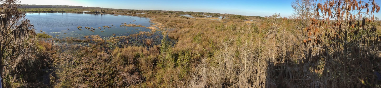
To really get the full effect and see this picture larger click here
After that, I made the long drive from south Georgia back home, even getting the pleasure of some Atlanta rush-hour traffic to welcome me back. Normally I eat a very health-conscious diet, and while I was backpacking my diet was pretty spartan, mostly things that could be made with boiling water or eaten plain. I couldn't help it but for lunch I stopped at Sonic for a double cheeseburger, fries and a cherry limeade. I say this with no shame, it was damn good!
Normally I close with a sunset shot, but I really
didn’t get any of those, but I did get a pretty nice sunrise photo from my
second morning on Cumberland Island, so I’ll leave you with that. Thanks for reading, Brandon.

wow-loved the story brandon-well wriiten and great images. makes us want to pak up and head east. thanks for letting us share in your adventure. i'm off solo next week to try and see the endangered golden-cheeked warbler and black-capped vireo in the tx hill country.
ReplyDeletedanny and maggie